Sunday, August 28, 2011

The Highline Trail (And all that that implies.)

First I have a trivia challenge for any of you who fancy yourselves movie buffs.  What movie does "And all that that implies" come from.  It's part of an answer after the question: "What does your daddy do?"
Anyway...
We drove back up the Going to the Sun Road to try the Highline Trail.  We were both a little nervous about it since neither one of us  likes heights.  But we decided not to let fear rule the day and started the hike.  Within a third of a mile we walked up to the first wall.

We walked on with a decided lean to the right and a hand close to or on the cable.  What we had read said the trail was about two feet wide, but most of this part was closer to four feet.  We made it past the wall and stopped to talk to a couple coming the other way.  They assured us that the trail got easier so we headed on. And they were right, partially.  Most of the entire trail was perched high on the mountain with certain death if a fall occurred.  And the next rock wall had no cable.  I guess they figured you would be used to the height by then.  


So we walked on and although we never got used to the height, we relaxed and enjoyed the hike.  Eight miles later we were back, tired and glad that we did it.   The views really were spectacular and the wildflowers were beautiful.


This was the only fairly level part of the hike just before we turned around.

And the answer to the trivia question:
Bud (Travolta) asked "What does your Daddy do?"  which was was answered by Pam.  She replied "My Daddy does oil.  And all that that implies."
Urban Cowboy

Saturday, August 27, 2011

Glacier 2

Today we hopped on the bike and headed back to Glacier for another try at getting through the gate before the sun went down.  And it worked.  We picked the correct lane and drove about 15 miles into the park to the trail-head for the Avalanche Trail, a moderate 5 mile loop (if you go all the way to the end of the lake).  There were quite a few hikers on the trail since this hike is one of the most popular.  And we could see why.

Despite being late in the season, the water was beautiful and fast.


A couple of views from the lake.  There were four waterfalls coming off the mountains.
Unfortunately the lighting angle was pretty poor for pictures.

Looking back the other way.

And a side view through the trees.  The water really looked like that.

A little friend that walked within five feet of us.  

And a last picture just before we got back to the bike.


Friday, August 26, 2011

Glacier

Val and I were excited to finally be driving in to Glacier this morning.  There was a long line going into the park and we chose the left lane as we approached the gate.  We noticed quickly that our line was a little slower than the right lane, but that's how it goes sometimes.  You know how it is.  You pick a line at the grocery store and it turns out that the checkout person is a trainee who has to look up every produce item you're buying and it takes 3 times longer than the other lines you could have picked.  Well, it turns out that our line was moving one eighth as fast as the other lane.  Trust me.  We had time to count.  Not that we were in a hurry, but we counted anyway.  Our guess was that we had a new ranger on our side.  We were wrong.  Or maybe not.  He could have  been new, but you couldn't tell that by his age.  We figured after having him check our pass and wave us through that he is one of the original rangers from when Glacier opened.  In 1932.  And he was probably 40 back then.  I kid you not.  I think we talked to the oldest person on earth.  And the slowest....
But we got in and headed up the Going to the Sun Highway to Logan Pass.  The first ten miles or so travel along Lake McDonald with the mountains reflecting on the water.  Then we started up the mountains and were greeted with amazing views.  Well, actually, Val was treated to amazing views.  I only got glimpses since taking my eyes off the road was not a good idea what with the rather large drop a few feet from my lane.  And little did we know that they have torn up several miles of the road way up near the top so that we were riding on dirt and gravel as we approached Logan Pass.  There were even two times that traffic was stopped because the road was down to a single lane.  Fun driving on a motorcycle, let me tell you.

The view as we waited for the road to open.

But we reached Logan Pass, took off our motorcycle gear, grabbed our lunch and headed out on the main trail from the visitors center.  Some clouds were present, but the chance of rain was only thirty percent.  And the clouds made for better pictures.  So we hiked and ate and marveled at the views.

We could see rain falling in the distance , but things seemed fine.

We got to see mountain goats.


And Bighorn sheep.

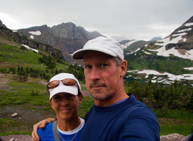
Val is happy to finally be here.

Actually, we both are.

But who wouldn't be with views like these.


At the top, right after we ate lunch, it started to rain a little, but nothing too threatening.  We started back down and then heard thunder.  It's not comforting to be on a mountain when there is lightening around which we started to see.  So we rather quickly descended to the visitor center where we were treated to a hard rain.  We rushed to get our rain jackets on and headed back down toward our campground.  Of course the unpaved parts of the road that we had traveled up were now unpaved mud.   But despite a little worry, we got back home intact, washed the bike which was covered in mud and grabbed two glasses of wine.  
Before we left this morning, a man we talked to at the campground said that going to Logan Pass would be a day to remember.  
He got that right.


Thursday, August 25, 2011

Update: All fixed and on the road.

We got our truck back a little before 12 today and are now all set up just a short 5 mile drive from Glacier National Park.  Finally.  We're too tired to explore the park today so the pictures here are from the last couple of days.

This is the river by our campground two days ago in Clinton, Montana. 

As we passed by the Bighorn Mountains we saw the strangest clouds we've ever seen.  The only word I can think of to describe them is ethereal.  The picture doesn't do them justice since I took it out of the truck window as we traveled, but you can kind of see the patterns.


Wednesday, August 24, 2011

So close, yet so far...

It started as a beautiful day.  We took an early morning walk by the river and took our time hooking up the RV since we only had three hours of driving to get to Glacier.  And then...
The clutch on the truck felt a little soft yesterday when I first drove it, but everything seemed fine all day.  This morning it felt soft again so as we drove toward Missoula Val checked the internet for a Volvo shop.  Lucky for us it was right in Missoula, so there would be no time wasted.  A quick stop and we hoped the clutch could be checked.  Well, we're now sitting in a very smokey  Missoula waiting for a new clutch and various other parts that go along with that.  Argh!  So close to Glacier, yet so far.  There is a slight chance that the repairs will be done today, but probably not.  The RV will stay at the Volvo shop and we'll stay in a hotel.  We would stay in the RV, but its so hot and we won't have electricity.  Another argh.
By the way, the smoke is from a wildfire right by Missoula, so even the ordinarily beautiful views are gone.  You already know what I'm thinking don't you....
Argh.

Tuesday, August 23, 2011

Wind Cave National park

A little more than an hour away from our campground was Wind Cave National Park.  Heard of it?  Probably not, but it was the first national park dedicated to caves.  There is of course lots of beautiful land above ground to explore with abundant wildlife, but the real treasure is below ground.
The Wind Cave name comes from the 18 inch hole in the ground that makes sounds as the air comes in and out depending on the weather above.  The wind can reach 70 mph if a strong pressure system comes through.  And that's how it was first discovered.  People in the area heard the wind and started to explore.  At that time, they were looking for gold.  There was none, but over the next 4 years one man mapped over 10 miles of cave.  Now they have mapped over 136 miles which makes it the fifth largest cave in the world.  And the latest study of the amount of air that goes in and out estimates that only 2-5% of the passageways have been discovered.  Amazing.
After riding the roads in the park, we paid to take a tour of the cave.  Val and I remember going to Luray Caverns when we were young, and that's what we imagined we would see.  Huge rooms with stalactites and stalagmites.  Beautiful rooms of lighted rock.  Uhh...nope. We knew things were going to be different when we first started to descend.  Small passageways where you ducked and turned became more small pathways.  It wouldn't help to be too claustrophobic.

Starting the descent.

 Minimal lighting allowed our eyes to adjust.  And we kept going down ending up 200 feet below the surface.

The rock formations were beautiful.  Because there is so little water, this cave doesn't have stalactites and stalagmites.  What it does have is 95% of the worlds boxwork, mineral deposites formed by erosion.  The early explorers thought that they were petrified cobwebs.

More of the amazing formations.

It was definitely a different experience from what I expected.  It was a fascinating tour and one that everyone who visits the area should experience.  There are four different tours including one that lasts four hours that takes you through tight areas where you need your headlamp and get to crawl and squeeze through passageways.  Nope.  I think I'll pass on that one when we go back.


Monday, August 22, 2011

Custer State Park & Mt. Rushmore

On Friday we took a chilly morning ride to Custer State Park  Now being used to 90 to 100 degree rides, we were surprised to get 63 degrees and cloudy for most of the day.  But what a ride it was.  Custer State Park is 71,000 acres of beauty.  We spent time on the wildlife loop and then rode the Needles Highway past rock formations and great vistas and through several small rock tunnels just big enough for one vehicle.

We were about 60 feet from this buffalo with it's two small calves.

The burros love the tourists, especially if they had food.

This formation made me think of Matt's bouldering.

The Needles.

One of the tunnels we went through.

And finally the requisite picture of Mt. Rushmore through the state flags.  It was great to see the real thing after reading about it since elementary school.


Thursday, August 18, 2011

Badlands Interior Campground parting shots

Today we move on to the area around Rapid City, SD.  So here are two shots I took from our campground yesterday.

Afternoon clouds moving over the Badlands.

As we watched the setting sun illuminate this cloud, we could see lightening flashes across the face and bursts of lightening from within.

Wednesday, August 17, 2011

A test of my riding skill.

The folks here at the campground suggested that we take a ride to Sheep Mountain Table about 40 miles away. They said that the trip would be worthwhile and that not many people travel there.  So this morning we took off on the first mostly cloudy day that we've seen here.  The wind was coming off the grassland at about 25 mph so the motorcycle ride was nice but you had to pay attention.  We did see three Pronghorn Antelope run across the road in front of us and lazily leap over a tall fence to enter the grasslands.  Beautiful animals.

When we arrived at the turnoff, we saw that the road was washboard gravel for as far as we could see.  But the promise of great views not seen by the masses made us head down the gravel road.  At the 4 mile mark there was a parking area.  That's where the road that continued got progressively worse.  There was a "high clearance vehicles only" sign at the start of the two track road.  We turned in to the parking area and met a man who had just walked part of the next section of road.  He assured us that our bike would do fine since we could stay in one rut.  Convinced, we headed off.  For the first mile or so it seemed reasonable.  Gravel, dried mud and the occasional path off the road to avoid huge ruts.  Then things got a little hairy as we hit patches of sand, something that I've never experienced before. Our beemer is a nice bike, but an off road bike it isn't.  Take off the fairings, raise the clearance, add some knobby tires and you have a bike that can and has traveled around the world as the BMW GS Adventure.  Of course it didn't help that I had a passenger aboard.  Nothing against Val, but it doesn't help to have extra weight being thrown around as the sand tried to steer us in all directions.  After about 2 miles and at a drop-off, I hit sand that almost turned the bike over the edge.  Val hopped off and helped push me back about 15 yards so that we could take a different path.  Val decided to stay off the bike until we could figure out how bad the conditions would get, and shortly after that I hit deep sand that stopped my completely.  Once again Val helped push me out of the sand, and I turned around and parked.

It turned out that we were just a half-mile from the top,  and when we arrived on foot we were treated to some fantastic views.  It was definitely worth the effort.  Once back to the bike, Val decided to walk about a mile of the road as I did my best to get the bike through the sandy parts.  It was a learning experience for me as it's been almost 45 years since I have ridden a dirt bike.  I'm glad I did it, but would probably not take that road again on a motorcycle.  Can you say Jeep?

The best of the road to the table.


Val helped push me back to this point.

One of the views from the top of the table.

A short rest on the edge before we headed back to the bike.

A last look.

Tuesday, August 16, 2011

Two ways to hike

Yesterday we decided to tackle part of the longest marked trail in the Badlands.  We set out about 8:30 to some clouds and a moderate breeze.  We planned on going out about 4 miles and looping back on another trail.  After the 4 miles, with stunning scenery at every turn, we decided to go straight through and then return using the added loop.  On the way out, we stopped often to snap pictures and take small excursions off the beaten path.  It was beautiful.  We enjoyed every bit of it and took a small break at the end before heading back.  Two miles into our return trek, we realized that it was, how should I phrase this, F*&^ING HOT!  The sky was cloudless and the wind had died.  It was now about 1:00 and it struck me that this is what you see in the old westerns when the good guy is robbed and left out in the sun to die.  We looked for shade to try to cool ourselves, but there was none.  Literally no shade for a couple of hours.   So the trip back was very different from the trip out.  Heads were down and the scenery passed with little notice.  Our goal?  Get back to the bike and get home.  And after 6 hours and over 12 miles we hopped on the bike, went to the campground, drank a lot more water and jumped in the small but very cold pool.  Whew.  No real harm done and lessons learned.  We will start out earlier and carry even more water.  I will say that my new hat helped although the number 45 sunscreen was outmatched by the sun on this day as we both got a little red.

The new hat did wonders.  

If the pool of water had been bigger, we may have joined this frog.  

We felt as baked as the ground in this picture about 8 miles into the hike.

A scene from the way out.

For Kathie and her love of animals.  This one seemed content to rest in the sun.


Sunday, August 14, 2011

At Last

After a 14 month delay, we're here in the Badlands.  This morning we rode a short 1.5 miles from our campground to the visitors center to talk to the rangers about the hiking trails.  We decided to hike the the Notch Trail first which was a spectacular start to our hikes in the park.  It's called a moderate hike due to the fact that there are a couple of tricky parts, but really it wasn't too difficult.

The first challenge is the ladder to the first ridge.

This a view looking toward our campground from the end of the marked trail.  The wooded area is known as a "slump".  It was formed by a huge rock formation breaking away and compacting the ground so that the vegetation could take hold and grow.

We ignored the trail markers and found another view.

Monday, August 8, 2011

RV Museum

Elkhart, if you didn't already know, is the hub of RV manufacturing.  Although our Teton was made in Casper, Wyoming, many of the big RV companies are located right here.  So while we were here as a captive audience, we took the bike to the RV/Motorhome Hall of Fame and Museum located a few miles from where we are staying.  It's a beautiful facility with RV's going back to 1913.  They also house the largest library of RV books and magazines that the Smithsonian has used many times in their own research.  It was a fun couple of hours seeing the way that our lifestyle has developed over the past century. I recommend it highly if you're in the area.

Excuse the pics, but I took them with my phone.

1913 travel trailer pulled by a Model T Ford.

Mae West's trailer.  She often put a rocking chair on the back porch while she talked to people.